
Home
- Table of Contents - OrderAquaMap™ is a complete subsea surveying system that makes
underwater mapping fast, precise, and repeatable. State-of-the-art SONAR technology
eliminates the need for survey lines and lets you map positions with sub-meter accuracy -
even in heavy weather. Fully computerized data handling speeds up analysis and
provides more consistent results. AquaMap™ - it's the new standard in
underwater surveying. 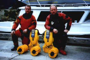 Enviro-Tech DiveTeam with AquaMap
System Ready For Surveying
Enviro-Tech DiveTeam with AquaMap
System Ready For Surveying
1.
Start Your Survey By Placing Two Or Three Baseline Stations. The baseline stations are the reference points for navigation. For best results, mount them in mid water near the corners of your survey area. The baseline stations are equipped with syntactic foam flotation collars which keep them stable in the water column. Several models of baseline stations are available. Use a smaller station such as RBS-1 which offers 20 hours of active operation per battery charge, or the larger RBS-2 which runs for 200 hours. All stations are equipped with a sleep mode, so you won't be burning power when no divers are in the water.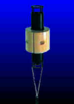 Baseline Station RBS-2 2. Now you are ready
to dive. A single diver can easily setup the baseline network and do the survey, or you
may use as many as 10 divers at a time. Divers can be tracked from the surface using an
optional surface station. A SONAR wake-up call issued at the
start of a dive by the diver or the surface station awakes the sleeping baseline stations.
Baseline Station RBS-2 2. Now you are ready
to dive. A single diver can easily setup the baseline network and do the survey, or you
may use as many as 10 divers at a time. Divers can be tracked from the surface using an
optional surface station. A SONAR wake-up call issued at the
start of a dive by the diver or the surface station awakes the sleeping baseline stations.
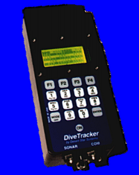 Diver Station DS-1
Following this, a diver station can conduct a baseline survey - automatically determining
the position of each baseline station. As little as one or as many as ten divers may be in
the water. The DS-1 diver station guides each diver along a string of
waypoints forming a survey pattern.
Diver Station DS-1
Following this, a diver station can conduct a baseline survey - automatically determining
the position of each baseline station. As little as one or as many as ten divers may be in
the water. The DS-1 diver station guides each diver along a string of
waypoints forming a survey pattern. 
Waypoints may also be defined for specific points of interest or the
diver may swim about freely. Once a diver reaches a survey point or encounters an object
of interest, he switches to the precision navigation screen. This screen shows the precise
X/Y position of the diver. 
The Position Error shows the quality of the position fix. Errors tend to
range from 0.15 meters to 1 meter for typical configurations. The diver now switches to
the custom observation screen. 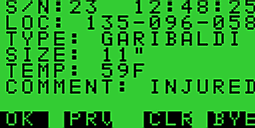
Numbers, text and items selected from lists are used to describe the observation. The
diver station automatically associates these observations with position, depth, water
temperature, time and even readings from sensors that are connected to the diver station.
All data is stored in the diver stations memory. Several thousand observations may be
stored before a download is necessary. The observation completed, the diver moves on to
the next survey point. Observation data is automatically associated with position, depth,
water temperature and a time tag. You are ready to move on to the next spot.
3. Upon return to the surface, the observation
recordings from the diver stations are downloaded to a personal computer. While the diver
enjoys a surface interval, the diver station is charged (90 minute charge time).
Everything is ready for another dive. 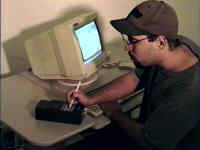
4. Observation data from several divers and dives
is merged to create a single file. Large scale surveys sometimes require moving the
baseline stations to different locations across the survey site. The Convert utility
creates a coherent data set by converting the X/Y coordinates into 'Northings' and
'Eastings' relative to your survey point of origin. The utility generates both a text
record as well as a data file that can be imported into most data bases, spreadsheets and
mapping systems. 
AquaMap diver survey systems can be upgraded for use in ROV based
precision surveys as well.
This entry level system is a good choice for short (one-day) surveys of sites up to 250 m x 250 m. We recommend it in particular for work in inland waters. The AM-1 consists of three model RBS-0 miniature baseline stations, one model DS-1 diver station and a full set of accessories. The system is shipped in a sturdy, waterproof carrying case.
Our most popular diver survey system, the AM-1 travels well and offers the reliability needed for everyday operation in the oceanic environment. The AM-1 consists of three model RBS-1 baseline stations, one model DS-1 diver station and a full set of accessories. The system is shipped in a sturdy, waterproof carrying case.
Your choice for extended mission duration's up to several weeks. The AM-2 consists of three model RBS-2 baseline stations, one model DS-1 diver station and a full set of accessories. The RBS-2 baseline station is good for 200 hours of survey work before the batteries need to be changed. A sturdy, waterproof shipping container protects the system during travel.