
Home
- Table of Contents - OrderAquaMap makes underwater surveying fast, repeatable
and precise. State of the art SONAR technology lets you map positions with sub-meter
accuracy, even in heavy weather. Fully computerized data handling speeds up analysis and
provides more consistent results. 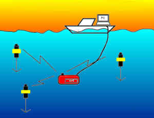
AquaMap for ROV operations uses a high precision wire synchronized system. The ROV interrogates each of the baseline stations to obtain its position. This position data along with any telemetry data needed is relayed through the umbilical to the surface terminal. This long baseline system eliminates the position uncertainty of surface vessel based sonar transducers. Precision adaptive sound speed estimation and a sliding average of multiple position fixes also improve accuracy. This is the system for you when your ROV job calls for surveying sea floor targets with sub-meter accuracy.
1.
Start Your Survey By Placing Two Or Three Baseline Stations. The baseline stations are the reference points for navigation. For best results, mount them in mid water near the corners of your survey area. The baseline stations are equipped with syntactic foam flotation collars which keep them stable in the water column. Several models of baseline stations are available. Use a smaller station such as RBS-1 which offers 20 hours of active operation per battery charge, or the larger RBS-2 which runs for 200 hours. All stations are equipped with a sleep mode, so you won't be burning power when no divers are in the water.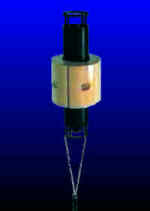
2.
Now you are ready to dive. The ROV is tracked from the surface by our sophisticated yet easy to use software DiveBase. DiveBase allows the ROV operator to track the vehicle and record observation data at specific points. Telemetry data from the ROV can also be displayed. DiveBase software runs on any IBM compatible computer running Windows 95 or NT.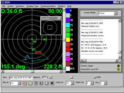
3. Observation data from
several dives is merged to create a single file. Large scale surveys sometimes require
moving the baseline stations to different locations across the survey site. The Convert
utility creates a coherent data set by converting the X/Y coordinates into 'Northings' and
'Eastings' relative to your survey point of origin. The utility generates both a text
record as well as a data file that can be imported into most data bases, spreadsheets and
mapping systems. 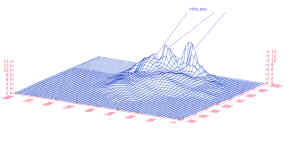
An AquaMap ROV system can be upgraded for use in diver based precision surveys as well.
The solution for economic ROV based precision surveys. The AM-11 system consists of three model RBS-1 baseline stations, one model VLT-3 ROV station, surface station software for Windows 94, 3.1 or NT and a full set of accessories. The system is shipped in a sturdy, waterproof carrying case.
Same as system AM-11, but including three model RBS-2 baseline stations The RBS-2 baseline station is good for 200 hours of survey work before the batteries need to be changed. A sturdy, waterproof shipping container protects the system during travel.